
What is Electromagnetic Conductivity (Terrain Conductivity)
Email us at whatisem@geophysicalsurveys.com
or Phone 703-777-9788
What is Electromagnetic Conductivity (EM) Terrain Conductivity
Electromagnetic conductivity (also known as terrain conductivity) measures the conductivity of the subsurface which includes soil, groundwater, rock, and objects buried in the ground. Geologic variations, groundwater contaminants, or any subsurface feature associated with changes in ground conductivity can be investigated using electromagnetic conductivity.
Conductivity is the inverse of resistivity; therefore, a low conductivity reading would be somewhat analagous to a high resistivity value. Sand, granite, dry subsurface soils, and neutral pH groundwater all have a relatively low conductivity. Clay, shale, high water content soils, low pH groundwater, and salty or briny groundwater, all have a relatively high conductivity.
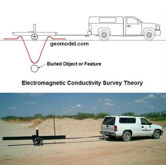
Generally, an electromagnetic conductivity (EM) instrument consists of a frequency-domain or time-domain conductivity meter. There are several companies that manufacture electromagnetic conductivity instruments worldwide. The instruments that GeoModel, Inc. owns and uses for conducting an electromagnetic conductivity survey are the Geonics EM31-DL and the Geonics EM61-MK2. GeoModel, Inc. uses the new EM61-MK2 which is twice as accurate as the standard EM61-MK2.
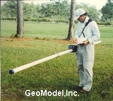
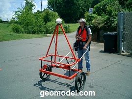
Above are the shallow (0' to 20') EM conductivity meter (white pole), the deeper (up to 100') EM conductivity meter (hoops), and the EM metal detector (0 to 10') being hand-towed. The EM instruments above are excelent for locating buried trenches, burial pits, landfills, and brine pits, and also the extent and depth of inorganic and salt plumes emanating from landfills, industrial ponds, and brine pits.
What is the EM31 Electromagnetic Conductivity (EM) Terrain Conductivity Meter
The EM31-DL is a frequency-domain instrument that can simultaneously measure the electromagnetic conductivity (terrain or ground conductivity) of the subsurface soil, rock, and groundwater (quadrature phase (quad-phase) component) and the magnetic susceptibility responses to any buried ferrous and non-ferrous metal (in-phase component), using a patented electromagnetic inductive technique.
Unlike the resistivity method, EM31 meter measurements can be made without electrodes or ground contact (non-destructive). EM31 surveys can be carried out over any surface conditions, and under most geologic conditions including those of high surface resistivity such as sand, gravel, asphalt, permafrost, and sea-ice.
Above is a photo of the truck-mounted 18-foot (6-meter) deep EM conductivity meter and also a representation of the EM response to a buried metal pipeline
The electromagnetic conductivity curve shown above is a typical EM31 response to buried metal when transversing perpendicular to the object's orientation. When advancing toward a buried metal object, the EM31 conductivity readings increase slightly at first and then rapidly decrease, sometimes below the background electromagnetic conductivity of the subsurface soils. As the EM31 instrument crosses the midpoint and retreats from the buried metal object, the electromagnetic conductivity response generally mirrors the advancing EM response. This inverse of EM readings over buried metal for the EM31 can be seen in EM31 color contour maps when surveying an area for underground metal utilities, buried electric cables, and landfills that contain buried metal.
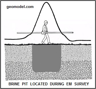
The EM31 curve shown below is a typical EM31 response to a high conductivity feature, such as a brine pit, that does not contain metal. The EM31 conductivity readings increase in relative proportion to the increase in pH of the soils and groundwater in the area of the high conductivity feature; in this case a brine pit.
The EM31-DL instrument has an optimum depth range of about 15 to 20 feet (6 meters). For locating metal objects, the signal response is stronger when the metal objects are either at shallow depth or are larger targets.
Compared to the surface resistivity method, the electromagnetic conductivity method can be performed more rapidly, small changes in conductivity can be measured with more precision, and the electromagnetic conductivity meter can take measurements and record EM data continuously while surveying an area. The EM31 also has the in-phase component which can detect buried metallic objects and structures simultaneously with the quad-phase (ground conductivity).
What is the EM61 Metal Detector
The EM61-MK2 is a high sensitivity, high resolution, time-domain metal detector which is used to detect both ferrous and non-ferrous metallic objects. The EM61-MK2 detector is more sensitive than the EM31-DL at shallower depths, and can pin point more accuately any smaller, more shallow metallic object. By using several passes at different orientations, calculations can be made in order to determine not only the location of a buried metal object, but also its approximate size, shape and orientation.
EM61-MK2 meters utilize a single, powerful transmitter coil that generates a pulsed primary magnetic field. This magnetic field induces eddy currents into nearby metallic objects. The decay of these eddy currents with time produces a secondary magnetic field. The time-decay of this secondary magnetic field generates a signal that is measured by two receiver coils mounted on the coil assembly. The EM61-MK2 Metal Detector provides up to four time gates of measurements for the decay of the secondary magnetic field associated with any metallic object.
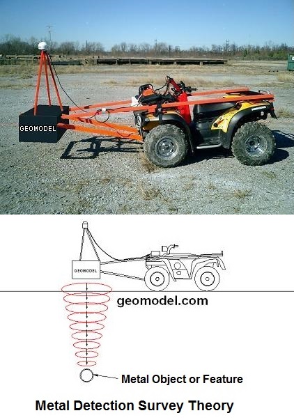
Vehicle-Mounted Shallow Pipeline Detection System (above) and Shallow EM Metal Detection Signal Transmission into the Subsurface (above)
When the EM61-MK2 passes over a buried metal target, the instrument response is a single, sharply defined high conductivity peak, the location of which can be quickly and accurately determined in the field or on a computer-generated contour map. The detection depth for the EM61-MK2 depends on the size and orientation of the object and other target characteristics. Geonics states that a single 55-gallon (200-liter) metal drum can be detected at depths greater than 10 feet (3 meters).
The Geonics EM31 and Geonics EM61-MK2 surveys can locate buried metal objects in most conditions. If the site is relatively free of cultural interference, including surface metal debris, wire fences, metal underground utilities, or overhead wires, the buried metal can be located.
How are Electromagnetic Conductivity Surveys Performed
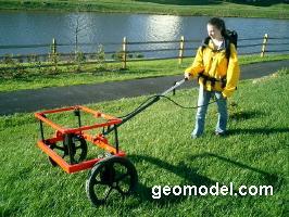
Electromagnetic conductivity (terrain conductivity) and metal detection surveys are rapid and very accurate. The EM instrument systems are easily hand-carried or moved around the site on a trailer or by mounting on a vehicle or ATV.
During field data collection, electromagnetic conductivity meters are usually connected to a digital data logger or a field computer for real-time display of EM readings or for recording the electromagnetic conductivity measurements for later downloading and processing. GPS (Global Positioning Systems) can be attached to the electromagnetic conductivity systems to automatically position the EM data in X and Y earth coordinates, and also obtain elevation, if desired.
A computer processed map of electromagnetic conductivity color contours can be generated from the EM data. This EM data color contour map is then examined for anomalies that represent subsurface features such as underground utilities, buried drums or USTs, conductive groundwater, contaminated soil, clay units, or buried metal debris.
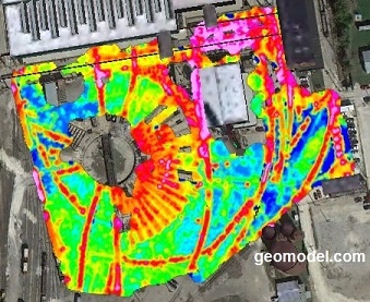
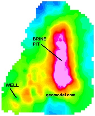
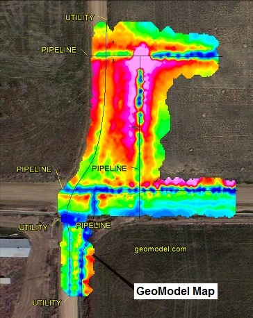
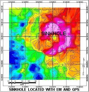
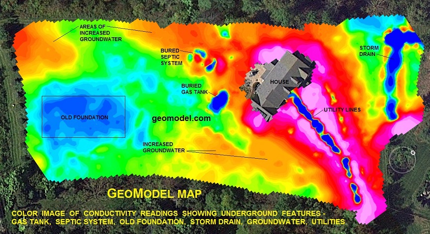
The color-contoured image (GeoModel Map) below was obtained using electromagnetic conductivity (EM) and GPS measurements. Because the electromagnetic conductivity method used was EM31, the underground metal pipelines have negative values represented by the dark blue colors in the center of the other colors.
GeoModel, Inc. has considerable geophysical experience and has conducted numerous electromagnetic conductivity (EM) surveys. EM surveys can be used to locate conductive underground structures, buried metal, underground utilities, buried drums, underground storage tanks, and other buried metal debris.
GeoModel, Inc. has also conducted EM surveys to determine the extent and depth of inorganic contaminant plumes, such as those emanating from industrial ponds and from landfills. Electromagnetic conductivity surveys are extremely useful in determining the extent of inorganic plumes at industrial facilities.
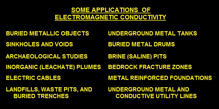
What can Electromagnetic Conductivity (Terrain Conductivity) be used to locate:
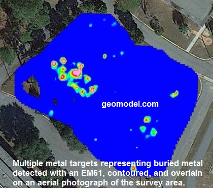
Examples of What Features Electromagnetic Conductivity Can Detect, Conducted by GeoModel, Inc.
GeoModel, Inc.'s professionals have successfully used Electromagnetic Conductivity methods to locate and delineate horizontal and vertical extents of buried metal (metallic objects), such as underground metal storage tanks, metal drums, buried metal utility lines and electric cables, landfills, waste pits, buried trenches, metal reinforced foundations, and archaeological sites, and high or low conductivity groundwater or soil, such as bedrock fracture zones, inorganic leachate plumes, sinkholes, brine pits, saltwater intrusion plumes, and other subsurface features and conditions. Some of these examples are shown below.
The yellow, orange, pink, and red colors represent increasingly higher levels of terrain conductivity and the green and blue shades correspond with diminishing levels of ground conductivity (blue or green being at or close to background, neutral pH, freshwater, or native conditions).

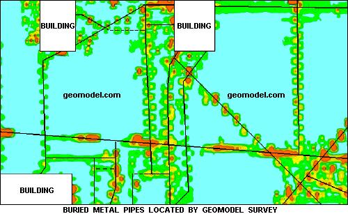
Using Electromganetic Conductivity to Locate Underground Metal Utilities, Buried Metal Drums, and Underground Storage Tanks
GeoModel, Inc. can create a color-contoured GeoModel Map underground scan of your property, using EM and metal detection instruments and computer processing to create a full color contour map showing areas of buried metal utilities, pipes, drums or tanks (USTs), burial trenches or landfills containing metal, or inorganic contamination.
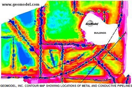
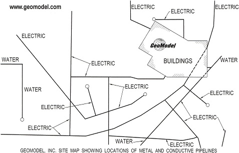
Color-contoured GeoModel, Inc. GeoModel Map (color map above) and site map (above) showing locations of metal, electrical, and conductive pipelines in the same area as on the color-contoured EM map.
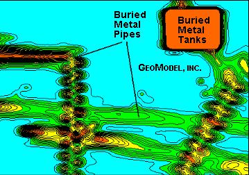
Another example (above) of locating metal and conductive pipelines, utilities, and other buried objects and features using electromagnetic conductivity (EM) methods.
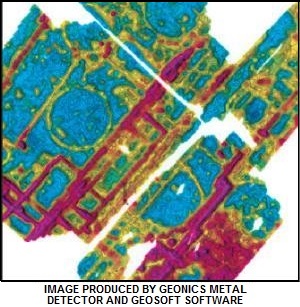
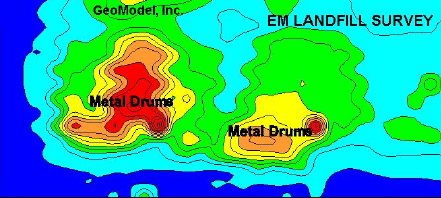
EM color-contoured results (below) at a site where steel drums were buried in concrete vaults in a landfill. Also below is an example color-contoured map showing the locations of USTs, associated piping, and other buried metal pipes.
Summary of What is Electromagnetic Conductivity and How It Works
Electromagnetic Conductivity (EM), also called Terrain or Ground Conductvity, is a non-destructive, geophysical method used to locate relatively high or low conductivity features, objects, or conditions underground. The electromagnetic conductivity instrument utilizes inductive methods and transmitter coils to generate a magnetic field into the ground. The magnetic field induces eddy currents that decay over time and produce a secondary magnetic field. The decay of the secondary magnetic field generates a signal that is measured by the electromagnetic conductivity meters.
The electromagnetic conductivity measurements produced by the EM instruments can be interpreted in the field to delineate buried metal objects, such as underground utilities, buried metal tanks or drums, or high conductivity features, such as brine pits, or low conductivity conditions, such as sand lenses. The EM data can also be recorded on a data logger and be downloaded to a computer to be processed, contoured, and interpreted.
This generalized discussion of the geophysical surveying method of electromagnetic conductivity and metal detection was prepared by GeoModel, Inc., founded in 1991 as a geophysical survey services and environmental consulting firm. The company principals have over 20 years of experience each in the geophysical surveying and environmental field and have conducted numerous electromagnetic conductivity (EM) (terrain conductivity) surveys worldwide. All EM projects are conducted or supervised by registered professional geologists.
GeoModel, Inc. conducts EM surveys in every state.
Contact us to check the availability of a crew in your state.
Click on your state below:
e-mail: ![]() whatisem@geophysicalsurveys.com
whatisem@geophysicalsurveys.com